
Choose your weapon


Your Dates & Locations:
-- > -- -- > -- ---- -- Days
Thanks!
We’re comparing ALL online rates to find you the best campervan deals.
Send us your full name on WhatsApp or Messenger & we’ll do the rest!
.png)

Sit tight
We're finding the best deals for you.
5.0 
3,000+ Google & Facebook reviews

10s
South Island has a way of making you feel very small. Snow-capped peaks that seem to go on forever, valleys carved out by glaciers, and coastline that looks like it was designed specifically to end up on someone’s phone wallpaper. And the best way to really see all of that? Get out of the car and walk.
Hiking New Zealand’s South Island was one of the highlights of my time in the country, and I’ve spent a fair bit of time there. From quick lakeside wanders to full multi-day treks through Fiordland, the trails here cover everything from gentle boardwalks to proper alpine scrambles. The range is genuinely impressive, and there’s something for every fitness level and timeframe.
This guide covers the hikes and walks that stuck with me most. I’ve broken it into day hikes and multi-day tracks, with practical details for each… Distance, time, difficulty, and the stuff that’s actually useful when you’re planning a trip. Whether you’re after a solid morning walk between drives or you want to spend three days in the backcountry, there will be something here for you.
Best Day Hikes on South Island
These are the walks you can do in a single day (or even a half-day) without needing hut bookings or overnight gear. Most are accessible from major towns along a South Island road trip, which makes them easy to slot into a driving itinerary.
Hooker Valley Track – Aoraki/Mount Cook
Distance: 10 km return | Time: 3 to 4 hours | Difficulty: Easy
This is the walk that makes everyone fall in love with Mount Cook. The track follows the Hooker River through the valley floor, crossing swing bridges with views of glaciers, ice-capped peaks, and, on a clear day, Aoraki (Mount Cook) towering above everything. The terrain is mostly flat and well-formed, making it accessible for families and anyone who prefers a walk over a full on hike.
Heads up: At the time of writing, the upper section of the Hooker Valley Track is closed while DOC (Department of Conservation) builds a new 189-metre suspension bridge, set to be the longest pedestrian suspension bridge in New Zealand! The lower section to Mueller Lake Lookout is still open, and the full track is expected to reopen sometime in 2026, likely in winter, though timelines may change. Always check the DOC website for the latest before heading out.
If you’re visiting while the upper track is closed, the Kea Point Track and Tasman Glacier Viewpoint are excellent alternatives in the same area.
Top tip: DOC introduced a paid parking trial at White Horse Hill car park in late 2025 ($5/hour or $25/day, card only). Be sure to plan accordingly.
Roys Peak- Wanaka
Distance: 16 km return | Time: 5 to 6 hours | Difficulty: Hard
If you’ve seen one photo of South Island hiking, there’s a solid chance it was taken at that viewpoint on Roys Peak. The 360° view over Lake Wanaka and across to Mount Aspiring National Park is genuinely as good as it looks online. The catch? You earn it. The trail is a relentless uphill switchback through farmland, roughly 1,300 metres of elevation gain, and there’s almost zero shade.
The famous photo spot is actually about 30 minutes before the summit, so if your legs are cooked by then, you can still get the shot and turn around.
Important: Roys Peak closes for lambing season, usually from around October to November. Check DOC and local signage before making the drive out there. And start early… The car park fills fast in summer and you’ll want to be heading up before the heat sets in.
Isthmus Peak – Lake Hawea
Distance: 16 km return | Time: 5 to 7 hours | Difficulty: Hard
If Roys Peak sounds like your kind of thing but you’d rather not share it with a hundred other people, Isthmus Peak is the answer. The effort is similar. Steep, exposed, and long, but you’ll see a fraction of the foot traffic. The reward at the top is a view over both Lake Wanaka and Lake Hawea, with the narrow land bridge between them stretched out below.
It’s a serious day out, and like Roys Peak there’s no shelter, so bring plenty of water and sun protection!
Rob Roy Glacier Track – Mount Aspiring National Park
Distance: 10 km return | Time: 3 to 4 hours | Difficulty: Moderate
This one punches well above its weight. A relatively short walk through native beech forest opens up into an alpine amphitheatre with the Rob Roy Glacier hanging right above you. Waterfalls pour off the rock face, and if you’re lucky you’ll hear chunks of ice breaking straight off the glacier.
The track starts from the Raspberry Creek car park in the Matukituki Valley. The access road is gravel and can be rough (check your rental vehicle agreement before driving out, as some companies restrict access on unsealed roads). It’s worth sussing out, because this walk delivers some of the most dramatic glacial scenery on South Island without requiring a multi-day commitment.
Key Summit – Fiordland
Distance: 6.6 km return | Time: 3 to 4 hours | Difficulty: Moderate
Key Summit is technically the first section of the Routeburn Track, but it works perfectly as a standalone day hike. The track climbs through beech forest to an alpine wetland at the top, where you get 360° views across the Hollyford Valley, the Darran Mountains, and back towards Lake Marian.
It’s one of those walks that gives you a genuine taste of what the multi-day Great Walks offer without requiring hut bookings or overnight gear. The trailhead is at The Divide, about an hour’s drive from Te Anau.
Ben Lomond Track – Queenstown
Distance: 11 to 14 km return (depending on starting point) | Time: 5 to 7 hours | Difficulty: Hard
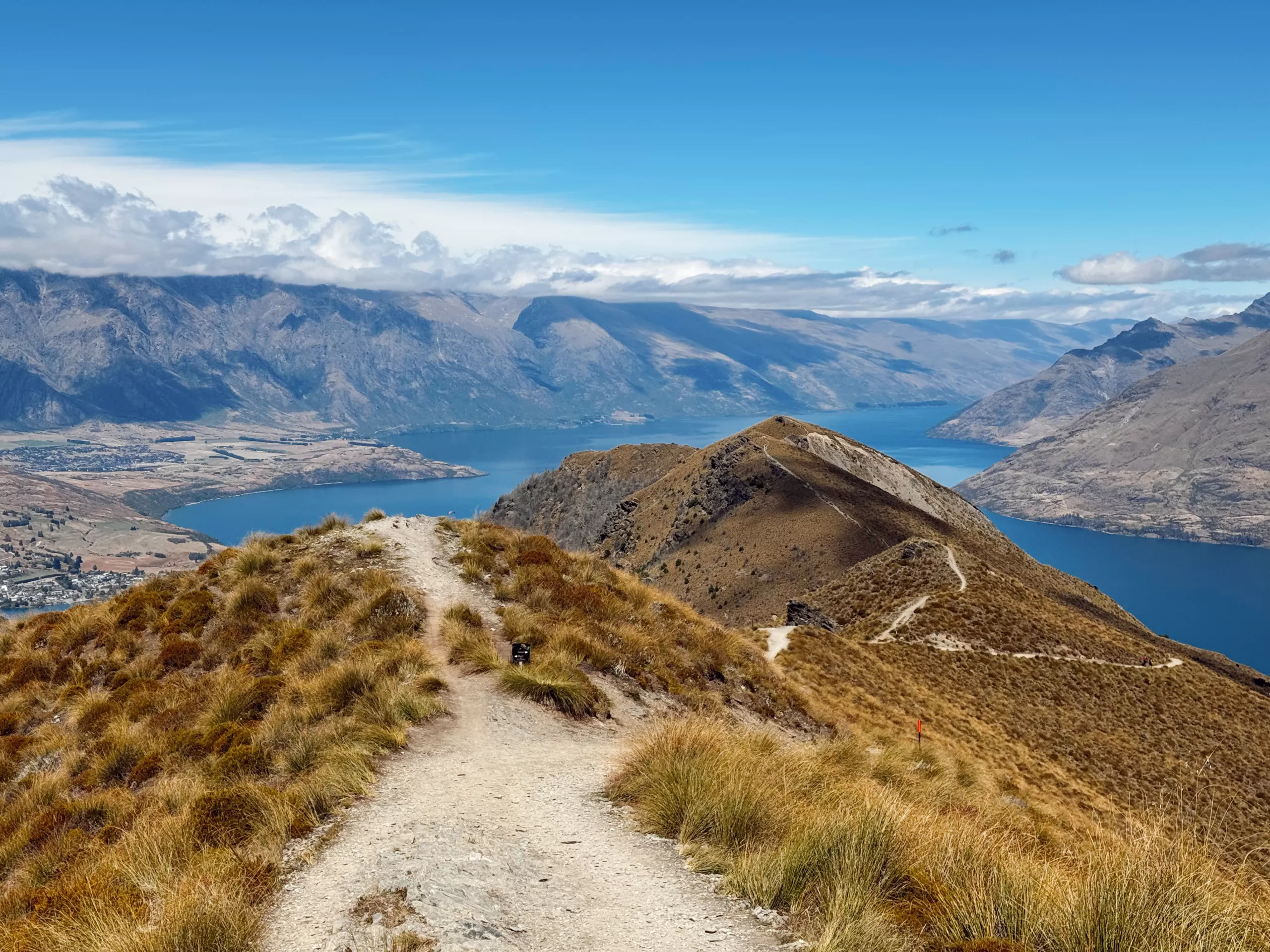
You can see Ben Lomond from just about everywhere in Queenstown, and climbing it is one of the best things to do in the area. The smartest approach is to take the Skyline Gondola up to the start, which saves you a solid chunk of elevation. From there, the track climbs through tussock and subalpine terrain to a summit with views over Lake Wakatipu, the Remarkables, and Queenstown itself.
The last section to the summit is steep and exposed, and weather can change quickly up there. But on a clear day, the views are extraordinary.
Sealy Tarns Track – Aoraki/Mount Cook
Distance: 3.6 km return | Time: 1.5 to 2.5 hours | Difficulty: Moderate to Hard
First things first, don’t let the short distance fool you. The Sealy Tarns Track is essentially a staircase – around 2,200 steps climbing steeply above the Hooker Valley. It’s a quad-burner, but the alpine tarn at the top and the views back down the valley are worth every step, I promise. On a clear day you can see right across to Aoraki/Mount Cook.
For stronger hikers, this track is also the start of the route to Mueller Hut – one of the most popular alpine hut experiences on South Island. (Mueller Hut requires a booking through DOC!)
Avalanche Peak – Arthur’s Pass
Distance: 6 km return | Time: 6 to 8 hours | Difficulty: Hard
Avalanche Peak is one of the more demanding day hikes on this list, but it’s also one of the most rewarding. The track rises steeply from the village of Arthur’s Pass through dense bush before breaking out above the treeline into serious alpine terrain. The summit views take in the surrounding peaks and valleys of Arthur’s Pass National Park.
Keep an eye out for kea (one of NZ’s many native birds) at the top – they’re curious, cheeky, and known for trying to dismantle unattended gear. So, don’t leave your pack open!
This one is for confident, experienced hikers. The track is steep, exposed in sections, and the weather at Arthur’s Pass can turn fast. Check conditions before you go and be prepared to turn back if needed.
Lake Marian – Fiordland
Distance: 6.4 km return | Time: 3 to 4 hours | Difficulty: Moderate
Lake Marian sits in a valley surrounded by steep mountain walls, and the whole scene genuinely looks like something out of a fantasy film. The track is short but rooty and muddy in places, so good footwear is a must. The payoff is a crystal-clear alpine lake that mirrors the peaks above.
The trailhead is on the road to Milford Sound, making it an easy addition to your roadie if you’re heading that way.
Best Multi-Day Hikes on South Island
South Island is home to some of New Zealand’s official Great Walks – premier multi-day tracks managed by the Department of Conservation. These require advance planning, hut or campsite bookings, and a bit more gear, but the experience is something else entirely.
Booking tip: Great Walk hut bookings usually open between May and June each year and popular dates sell out fast. Set your DOC profile up in advance and be ready on opening day. The dates are staggered across different tracks, so be sure to check the schedule.
Routeburn Track
Distance: 32 km one way | Duration: 2 to 4 days | Difficulty: Moderate
The Routeburn runs between Mount Aspiring and Fiordland National Parks, crossing alpine saddles, skirting mountain lakes, and passing through ancient beech forest. It’s consistently rated as one of the most scenic multi-day walks in the country. The alpine section across Harris Saddle and the Hollyford Face is a genuine highlight.
Because it’s a one-way track, you’ll need to organise transport at either end. Shuttle services run between the Routeburn Shelter and The Divide during the Great Walk season.
Milford Track
Distance: 53.5 km one way | Duration: 4 days | Difficulty: Moderate
Often described as ‘the finest walk in the world’ (and honestly, it’s hard to argue), the Milford Track takes you from the head of Lake Te Anau through rainforest and over Mackinnon Pass before finishing at Milford Sound. Sutherland Falls (one of New Zealand’s tallest waterfalls) is a side trip along the way.
This is probably the most sought-after Great Walk booking on South Island. Numbers are strictly limited, so I recommend planning well ahead. You’ll need a water taxi to the start and a boat from Sandfly Point at the end.
Kepler Track
Distance: 60 km loop | Duration: 3 to 4 days | Difficulty: Moderate
The Kepler is a loop track, which means no shuttle logistics, you start and finish at the same spot near Te Anau. The route climbs to an exposed alpine ridgeline with views across Lake Te Anau and the surrounding ranges, before dropping into beech forest and following the lakeshore back.
It’s a well-formed track and a great option if you want a multi-day Great Walk experience without the one-way transport complications.
Abel Tasman Coast Track- Nelson/Tasman
Distance: 60 km one way | Duration: 3 to 5 days | Difficulty: Easy to Moderate
The Abel Tasman is the most accessible of the Great Walks and the only one on this list that’s primarily coastal. Golden sand beaches, clear turquoise water, and native bush (it’s a completely different vibe from the alpine tracks further south). Water taxis run along the coast, so you can walk as much or as little as you like and get picked up or dropped off at various bays.
It’s a strong option for families or anyone who wants a multi-day walk without serious elevation or rough terrain.
Tuatapere Hump Ridge Track- Fiordland
Distance: 61 km loop | Duration: 3 days | Difficulty: Moderate to Hard
The newest addition to the Great Walk family, officially opening in October 2024, the Hump Ridge Track is still flying under the radar compared to the Milford and Routeburn. And to be honest, that’s part of its appeal. The three-day loop takes you along rugged Fiordland coastline, up through subalpine terrain, and across historic viaducts in dense native forest.
What sets it apart from other Great Walks is the accommodation. The two lodges (Okaka and Port Craig) are run by a charitable trust and offer hot showers, comfy beds, and even a bar! A far cry from the typical DOC hut experience. You can opt for a basic bunk or upgrade to a private room.
The first day involves a serious climb – almost 1,000 metres of elevation – so bring your hill-climbing legs. But the coastal views from the ridgeline and the sense of remoteness in southern Fiordland make it worth every step.
Booking tip: Hump Ridge Track bookings are handled through the Hump Ridge Trust website, not through the standard DOC booking system.
Practical Tips for Hiking South Island
A few things that are worth knowing before you lace up your walking boots.
The weather changes fast. South Island mountains can throw four seasons at you in a single day, so layers are essential – even in summer. My advice – pack a rain jacket regardless of the forecast.
Sandflies are real. Especially on the West Coast and in Fiordland. Bring strong insect repellent and apply it generously. Long sleeves at dawn and dusk help too.
Check DOC before every walk. Track conditions, closures, and alerts are updated regularly on the Department of Conservation website. This is especially important for alpine tracks and after heavy rain.
Kea will investigate your gear. These alpine parrots are intelligent, curious, and surprisingly destructive. Don’t leave packs, boots, or gear unattended at altitude…
Water safety. Not all waterways in New Zealand are safe to drink from, so carry enough water for your hike and treat any water collected from streams before drinking.
Start early. For popular tracks like Roys Peak and the Hooker Valley, arriving at the car park before 8am (and even earlier in peak summer) makes a real difference, both for parking and for having the trail more to yourself.
Pack properly. If you’re planning a South Island road trip by campervan, we’ve got a full campervan packing list that covers hiking essentials alongside everything else you’ll need on the road.
Hiking South Island by Campervan
A campervan is honestly one of the best ways to do South Island if hiking is up there on your list. Trailheads are spread across the island – from Arthur’s Pass to Fiordland to Mount Cook – and having your own wheels (and your own bed) means you can move at your own pace, park up near the trail, and get an early start the next morning to beat the crowds.
You can hire a campervan in Christchurch or Queenstown and build a route around the walks that interest you most. If you’re covering the full island, we’ve put together a guide to places not to miss in New Zealand that pairs super well with a hiking-focused trip.
And if you’re thinking about freedom camping between hikes (I’d 100% recommend this), it’s worth reading up on the current rules around freedom camping in NZ – as the regulations have tightened in recent years, and no one wants to be stung with a hefty fine.
FAQs
Do I need a permit for day hikes on South Island? Most day hikes don’t require a permit or booking. The main exceptions are the Great Walks (which need hut/campsite bookings for overnight stays) and Mueller Hut, which requires a DOC booking. Some tracks cross private farmland and may close seasonally.
Is it safe to hike solo on South Island? Generally yes, particularly on well-known tracks like the Hooker Valley, Roys Peak, and Key Summit. For more remote or alpine hikes, it’s always safer with a partner. Regardless of whether you’re solo or in a group, tell someone your plans, carry a charged phone, and consider a Personal Locator Beacon (PLB) for backcountry tracks. Tip: PLBs can be rented from DOC visitor centres and outdoor shops.
When is the best time for hiking in South Island? Summer (December to February) gives you the longest days and the warmest temperatures. March and April are often excellent too with fewer crowds, settled weather, and those amazing autumn colours in the beech forests. Winter hiking is possible but conditions can be icy at altitude, and some tracks close or become significantly more dangerous. So always check conditions before heading out.
How do I get to trailheads without a car? Some trailheads (like Key Summit and the Milford Track) are accessible by shuttle services from nearby towns. But for most of the hikes on this list, having your own vehicle makes things significantly easier. A campervan hire in New Zealand gives you the flexibility to reach trailheads on your own schedule.
Can I drink the water on the trails? Water from hut taps is generally safe. Stream and river water should be treated or filtered before drinking. Carry enough water for your hike, especially on exposed tracks like Roys Peak and Isthmus Peak where there are no water sources on the trail.
Start Planning Your South Island Hiking Trip
South Island’s trails are genuinely world-class, and building a trip around them is one of the best ways to experience the island. Whether you’re after a few solid day hikes between scenic drives or you want to tackle one of the Great Walks, having the right setup makes all the difference.
If you’re thinking about doing it by campervan (and I’d recommend it) send us your travel dates and we’ll build you a personalised camper deal with the best value guarantee, tailored to your trip. We’ve done these roads and these trails ourselves, so we can help you plan a route that actually makes sense around the hikes you want to do.
About the Author

with RatPack Travel?

5-Star Google Rated
5-Star Google Rated


Our Customers Say it Best